Posted by Olivia W on Wednesday, May 17, 2023
The last of the plat maps, although the one with the least amount of information, was fairly easy to research.

There is no title on this map, and there are no official names or dates. The only information present are the features of the map itself. Even though I started with very little information, I was able to find a much narrower ranger of possible creation dates than I could with the previous map.

The Iowa City Municipal Airport was built in 1918, so the map must have been created after 1918. In a bit of a jump, the subdivisions of Plum Grove Acres and Douglas Ct & St were platted after 1945. Neither of those subdivisions are listed on a 1947 map of Iowa City that was created by the City Engineer, so this map was likely created after 1947.
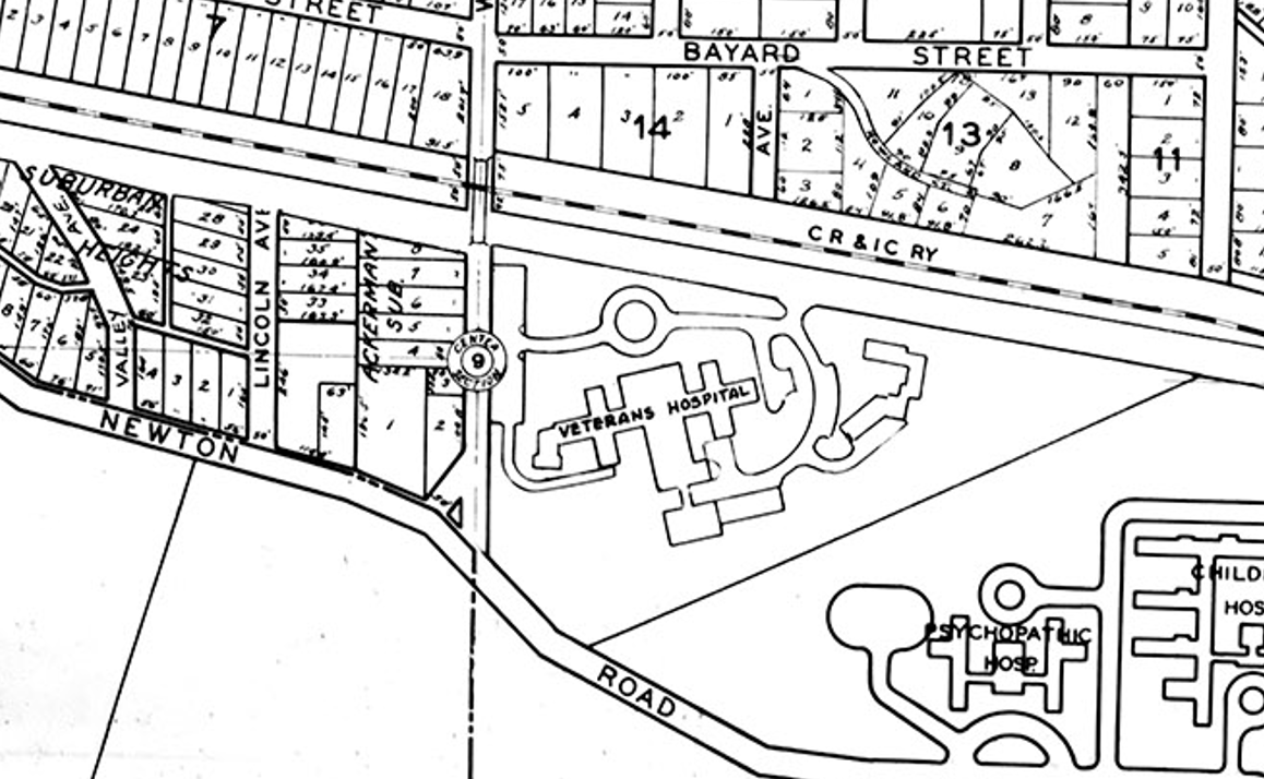
In another jump, the Veteran’s Hospital wasn’t fully constructed until late 1951, so the map would have been created after 1951. Finally, the map has the Quadrangle and Hillcrest Hall, both University of Iowa Residence Halls, listed on it. However, it doesn’t list Parklawn, another University Residence Hall that was built in 1955. So, I can say that this map was likely created between 1951 and 1955.
Since I was able to provide a small date range for the creation of this map, I am also able to name the City Engineer who would have been involved with a fair amount of certainty. It helps that there was not a high rate of turn-over during this period. The City Engineer who likely helped create this map was Fred Gartzke, who held his position from 1933-1962.

Although this map doesn’t include as many features as the previous maps, it was still likely an official map used by the City of Iowa City. The features included on this map are section lines, lot lines, and property lines, street and subdivision names, plot numbers, railroads, and prominent landmarks.
For a bit of fun, I’m including a little information on a fourth historical map in the Iowa City Public Library’s collection. This is not a plat map, rather it is a very early map of Iowa City that displays some of the prominent land marks. The map is titled “Iowa City and Its Environs”, and it was published in 1854. It was compiled and drawn by J.H. Millar and illustrated by G.H. Yewel. This map is currently hanging in the Board Room on the second floor, and while ICPL doesn’t have a digitized copy, you can find a high-resolution scan of the map in the University of Iowa’s Digital Library.

The reason for including this map is that there is a record of its donation to ICPL. The Iowa City Press Citizen published an article in 1922 that documented the donation of this map to ICPL from an insurance agent, Jerry Holland. This sort of documentation is fairly rare, and I haven’t been able to find anything of the sort for the previous three maps!
Historical Maps Collection Overview ; Historical Maps Collection - A Map of Iowa City, Iowa ; Historical Maps Collection - A Map of the West Side
Sources:
“Iowa City airport celebrates 100 years.” (2018, Jan 21) The Gazette. Retrieved from https://www.thegazette.com/government-politics/iowa-city-airport-celebrates-100-years/
University of Iowa Hospitals and Clinics. (2022) “History.” Retrieved from https://uihc.org/history
Frederick W. Kent. (1951, Jul) “Veterans Hospital Under Construction.” Retrieved from https://digital.lib.uiowa.edu/islandora/object/ui%3Aictcs_573
University of Iowa Facilities Management. “Parklawn Hall.” Retrieved from https://www.facilities.uiowa.edu/building/0121
“Deaths / Eastern Iowa.” (1988, Jan 07) Cedar Rapids Gazette. Retrieved from Newspaper Archive via the Iowa City Public Library.
"New Mayor Appoints Harlan F. Sprinkle I.C. Chief of Police." (1943, Apr 06) The Daily Iowan. Retrieved from Newspaper Archive via the Iowa City Public Library.
J.H. Millar (Cartographer). 1854. “Iowa City and Its Environs.” Retrieved from https://digital.lib.uiowa.edu/islandora/object/ui%3Asheetmaps_76
“Ancient Map 68 Years Old.” (1922, Aug 23) Iowa City Press Citizen. Retrieved from Historical Iowa City Newspapers via the Iowa City Public Library.
“Plum Grove to Become Historical Shrine Tomorrow.” (1946, Nov 01). Iowa City Press Citizen. Retrieved from Newspaper Archive via the Iowa City Public Library.
City Engineer’s Office (Cartographer). 1947. “Iowa City.” Retrieved from https://digital.lib.uiowa.edu/islandora/object/ui%3Asheetmaps_84